
The largest rift valley in Africa and one of the most dramatic geological features on Earth is the East African Rift System, a massive scar stretching thousands of kilometers across the continent. If you are searching for clear, updated, and comprehensive information on what the largest rift valley in Africa is, how it formed, why it matters, and what makes it globally significant, the answer begins with understanding that this rift is not a single valley, but a vast interconnected system created by deep tectonic forces slowly tearing a continent apart. The East African Rift System is, quite simply, the continent’s most monumental natural divide—one that shapes landscapes, climates, ecosystems, and human settlements on a continental scale.
Introduction
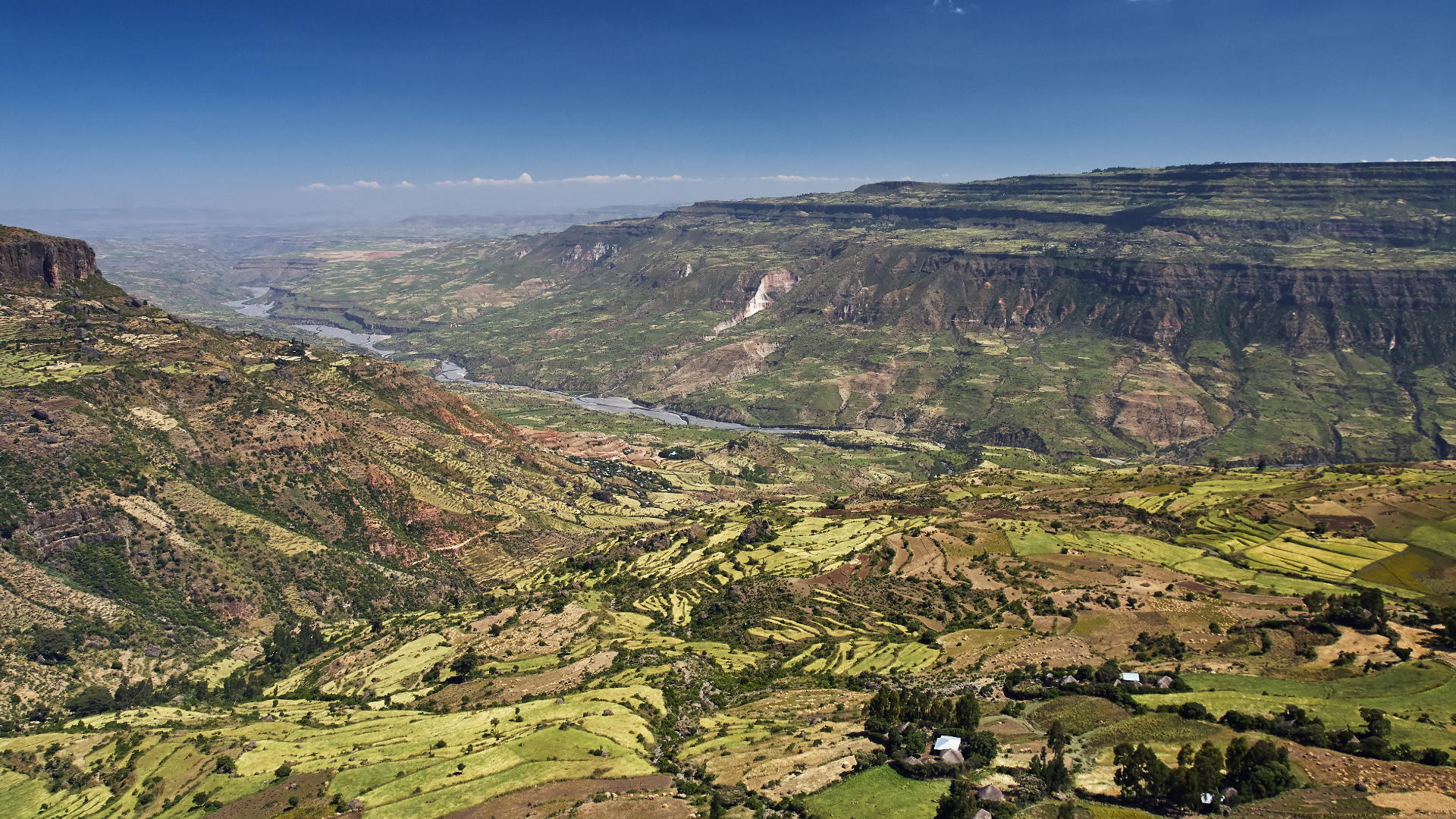
The phrase “largest rift valley in Africa” refers to a geological marvel that stretches from the Afar Triangle in northeastern Ethiopia all the way down toward Mozambique. This immense geological structure is not only the most expansive rift valley on the African continent but also one of the planet’s most active tectonic zones. It influences everything around it mountain ranges, deep freshwater lakes, volcanic fields, fertile farmlands, and long migration paths carved by ancient humans. Scientists believe the East African Rift System provides a rare snapshot into the early stages of continental breakup a process that, millions of years from now, could split Africa into two separate landmasses. But beyond the scientific intrigue, the rift valley is equally important culturally, ecologically, and historically. It nurtures some of Earth’s richest wildlife ecosystems, shelters some of humankind’s earliest ancestors, and creates a ribbon of varied sceneries ranging from volcanoes to lush lakeshores.
This article examines the East African Rift System through multiple lenses: geological formation, physical structure, regional divisions, biodiversity, human history, modern significance, and environmental challenges.
Key Facts About the Largest Rift Valley in Africa
| Feature | Description |
|---|---|
| Official Name | East African Rift System (EARS) |
| Geological Type | Divergent tectonic plate boundary (continental rift) |
| Length | Over 6,000 km from Red Sea/Afar Triangle to Mozambique |
| Countries Included | Ethiopia, Eritrea, Djibouti, Kenya, Uganda, Tanzania, Malawi, Mozambique |
| Major Sub-Rifts | Eastern Rift (Gregory Rift), Western Rift (Albertine Rift) |
| Most Famous Lakes | Lake Tanganyika, Lake Malawi, Lake Albert, Lake Turkana |
| Major Volcanoes | Mount Kilimanjaro, Mount Kenya, Mount Meru, Erta Ale, Ol Doinyo Lengai |
| Age | Began forming about 25–30 million years ago; still developing |
| Global Importance | Biodiversity hotspot, cradle of humankind, active tectonic laboratory |
| Future Outlook | Potential continental split forming a new ocean in several million years |
Understanding How the Rift Formed
The East African Rift System exists because the African Plate is slowly splitting into two smaller plates, often referred to as the Nubian Plate and the Somali Plate. This process resembles a deep fracture in the Earth’s crust, where forces pull land apart, allowing magma to rise and reshape the surface.
Tectonic Forces at Work
The rift has no single cause; instead, it emerges from a combination of:
- Mantle plumes heating the crust from below
- Tectonic extension pulling plates in opposite directions
- Volcanic upwelling weakening the crust
- Long-term geological stress stretching the continent
Because the crust here thins progressively, deep basins form, eventually becoming valleys or filling with water to create lakes. This explains why so many of Africa’s deepest and longest lakes lie directly within the rift.
A Landscape in Motion
Although the rift moves slowly only a few millimeters per year the long-term consequences are massive. Over millions of years, the rift could widen enough for seawater to flood it, forming a new ocean. This process is similar to what happened when the Red Sea opened or when South America drifted away from Africa.
Two Branches: Eastern and Western Rift
The East African Rift System is divided into two major segments:
The Eastern Rift (Gregory Rift)
This eastern branch runs through Ethiopia, Kenya, and Tanzania. It is home to:
- major volcanoes like Kilimanjaro and Mount Kenya
- the vast Turkana Basin
- alkaline lakes such as Lake Nakuru
The Eastern Rift is generally more volcanically active, with dramatic calderas and lava fields.
The Western Rift (Albertine Rift)
This branch runs along the borders of Uganda, Rwanda, Burundi, Tanzania, and the DRC. It is known for:
- some of the world’s deepest lakes (Tanganyika, Malawi, Kivu)
- steep, majestic escarpments
- gorilla-rich forests in the Virunga Mountains
The Western Rift is less volcanic but hosts extremely deep lake basins formed by intense tectonic stretching.
The Rift’s Great Lakes: Deep, Old, and Ecologically Vital
Some of Earth’s most important freshwater bodies lie within the rift system.
Lake Tanganyika
- Second-deepest lake in the world
- Extremely biodiverse
- Formed by continuous rifting for millions of years
Lake Malawi
- One of the world’s most fish-diverse lakes
- Central to understanding early human migrations
Lake Turkana
- Largest permanent desert lake
- Critical archaeological discoveries found along its shores
These lakes act as natural laboratories for evolution and climate study.
Volcanoes of the Rift: Landscapes Shaped by Fire
Volcanism is one of the rift’s most visible signatures. Some notable examples include:
- Erta Ale (Ethiopia): one of the few constantly active lava lakes
- Ol Doinyo Lengai (Tanzania): the world’s only natrocarbonatite volcano
- Mount Kilimanjaro (Tanzania): highest mountain in Africa
- Mount Meru (Tanzania): a near-perfect stratovolcano
Volcanic eruptions enrich soil, making the rift valley one of Africa’s most fertile regions.
A Cradle of Humanity
The East African Rift is central to the story of human evolution. Numerous paleoanthropological sites including Olduvai Gorge, the Omo Valley, and Lake Turkana’s ancient basins hold fossils that reveal early human origins.
Some of the earliest hominins discovered within this region include:
- Australopithecus afarensis (“Lucy”)
- Homo habilis
- Homo erectus
The rift valley provided diverse landscapes that influenced early human development, offering water, shelter, and shifting ecosystems that encouraged adaptation.
Ecosystems and Biodiversity of the Rift Valley
The rift valley hosts varied ecosystems, including:
- montane forests
- savannas
- alkaline lakes
- volcanic highlands
- freshwater wetlands
These environments support incredible biodiversity:
- elephants, lions, leopards
- mountain gorillas and chimpanzees
- thousands of bird species
- unique lake fish species
- rare plants adapted to volcanic soils
Protected areas like Serengeti, Ngorongoro, Virunga, and Queen Elizabeth National Park lie within or along the rift.
Human Cultures and Civilizations Along the Rift
For thousands of years, communities have used the rift valley’s fertile soils, fresh waters, and migratory corridors. Today it supports millions of people engaged in:
- agriculture
- pastoralism
- fishing
- geothermal energy production
- tourism
From the ancient kingdoms around Lake Victoria to modern cities such as Nairobi and Addis Ababa, the rift has shaped civilizations both ancient and modern.
Scientific Importance: A Living Geological Laboratory
Researchers study the rift valley to understand:
- continental breakup
- volcanic systems
- ancient climate records
- human evolution
- earthquake mechanics
Because the rift is active, it offers real-time insights into processes normally inferred only from ancient rock layers elsewhere.
Environmental Challenges
The rift valley, while magnificent, faces challenges:
- deforestation
- overfishing
- volcanic hazards
- seismic activity
- population pressure
- climate change affecting lakes
Balancing conservation with human development is essential.
Future Outlook: Africa’s Slow Continental Transformation
If tectonic movement continues, eastern Africa may eventually separate from the rest of the continent. Scientists predict:
- widening rifts
- increased volcanic activity
- eventual oceanic flooding
This transformation will take tens of millions of years, but the early stages are playing out now.
Conclusion
The largest rift valley in Africa, the East African Rift System, is one of the most dramatic, scientifically important, and culturally rich geographic features on Earth. Stretching for thousands of kilometers, it connects extraordinary landscapes from volcanic highlands to deep freshwater lakes and preserves a rich record of both natural and human history. Understanding the rift is understanding Africa itself: dynamic, diverse, evolving, and deeply connected to the forces that shape our planet.